
Thank you for supporting this site ❤️
Make a donation
Make a donation
Gear up for your next adventure:
As an Amazon Associate, this site earns from qualifying purchases at no extra cost to you.
Urtei/Bultei topographic map
Click on the map to display elevation.
Thank you for supporting this site ❤️
Make a donation
Make a donation
Gear up for your next adventure:
As an Amazon Associate, this site earns from qualifying purchases at no extra cost to you.
About this map
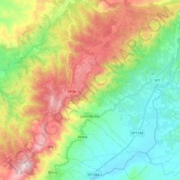
Name: Urtei/Bultei topographic map, elevation, terrain.
Location: Urtei/Bultei, Sassari, Sardinien, 07010, Italien (40.41138 8.99715 40.53769 9.15529)
Average elevation: 616 m
Minimum elevation: 235 m
Maximum elevation: 1,252 m
Thank you for supporting this site ❤️
Make a donation
Make a donation
Gear up for your next adventure:
As an Amazon Associate, this site earns from qualifying purchases at no extra cost to you.