Geolocate

Goblin Valley topographic map

Click on the map to display elevation.

About this map

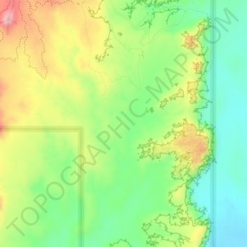
Name: Goblin Valley topographic map, elevation, terrain.

Location: Goblin Valley, Emery County, Utah, United States (38.54643 -110.71596 38.56643 -110.69596)

Average elevation: 1,503 m

Minimum elevation: 1,438 m

Maximum elevation: 1,593 m

Other topographic maps

Click on a map to view its topography, its elevation and its terrain.

Ferron

United States > Utah > Emery County

Average elevation: 1,822 m

Green River

United States > Utah > Emery County

Average elevation: 1,349 m

Gear up for your next adventure:

🥾Lightweight Hiking Boots - Boots for comfort and mobility on long hikes
🥾Hiking Gaiters - Protect legs and shoes from mud, snow, and debris
🥾Lightweight Hiking Shoes - Comfortable shoes for day hikes
💡LED Camping Lantern - Illuminate your campsite with long-lasting lanterns
🛌Insulated Sleeping Pad - Critical thermal barrier between you and the cold ground

As an Amazon Associate, this site earns from qualifying purchases at no extra cost to you.