Geolocate

Orito topographic map

Click on the map to display elevation.

About this map

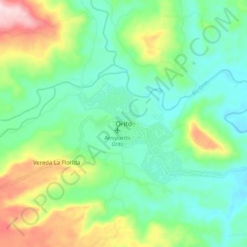
Name: Orito topographic map, elevation, terrain.

Location: Orito, Putumayo, Colombia (0.62867 -76.91497 0.70867 -76.83497)

Average elevation: 377 m

Minimum elevation: 285 m

Maximum elevation: 590 m

Gear up for your next adventure:

🛶Waterproof Dry Bags - Keep electronics and clothes dry during river crossings
🧦Outdoor Socks - Durable socks designed for hiking and outdoor sports
🔭Outdoor Binoculars - Lightweight binoculars for birdwatching and hiking
🥾Trail Running Boots - Durable shoes designed for trail running
🥾Mountain Trail Shoes - High-traction shoes for mountain trails

As an Amazon Associate, this site earns from qualifying purchases at no extra cost to you.