Geolocate

Vancleave topographic map

Click on the map to display elevation.

About this map

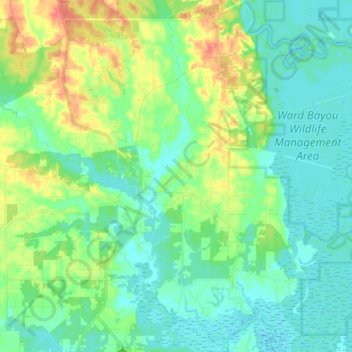
Name: Vancleave topographic map, elevation, terrain.

Location: Vancleave, Jackson County, Mississippi, 39565, United States (30.47313 -88.73354 30.61075 -88.60863)

Average elevation: 13 m

Minimum elevation: -3 m

Maximum elevation: 43 m

Other topographic maps

Click on a map to view its topography, its elevation and its terrain.

Harleston

United States > Mississippi > Jackson County

Average elevation: 36 m

Hurley

United States > Mississippi > Jackson County > Hurley

Average elevation: 23 m

Gear up for your next adventure:

🧤Insulated Winter Gloves - Heavy-duty protection for sub-zero Canadian adventures
🧴Waterproofing Spray - Restore the DWR coating on jackets and tents
🎒Hiking Backpack - Lightweight and ergonomic backpacks for day hikes or multi-day treks
🥾Trekking Boots - Durable boots for long-distance trekking
🥾Waterproof Hiking Boots - Boots keeping your feet dry in wet conditions

As an Amazon Associate, this site earns from qualifying purchases at no extra cost to you.