
Make a donation
Gear up for your next adventure:
As an Amazon Associate, this site earns from qualifying purchases at no extra cost to you.
Callian topographic map
Click on the map to display elevation.
Make a donation
Gear up for your next adventure:
As an Amazon Associate, this site earns from qualifying purchases at no extra cost to you.
Callian
Callian strekt zich uit over een heuvel en huizen liggen dan ook op zeer uiteenlopende hoogtes: tussen de 104 en 579 meter boven zeeniveau.
Make a donation
Gear up for your next adventure:
As an Amazon Associate, this site earns from qualifying purchases at no extra cost to you.
About this map
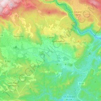
Name: Callian topographic map, elevation, terrain.
Average elevation: 307 m
Minimum elevation: 83 m
Maximum elevation: 769 m
Make a donation
Gear up for your next adventure:
As an Amazon Associate, this site earns from qualifying purchases at no extra cost to you.
Other topographic maps
Click on a map to view its topography, its elevation and its terrain.
Lotissement "Les Hameaux du Golf"
Frankrijk > Provence-Alpes-Côte d'Azur > Var > Sainte-Maxime
Average elevation: 80 m
Paris Plage
Frankrijk > Provence-Alpes-Côte d'Azur > Var > Sainte-Maxime > Gauthier-Haut
Average elevation: 22 m
Les Mas de Guerrevieille
Frankrijk > Provence-Alpes-Côte d'Azur > Var > Sainte-Maxime
Average elevation: 60 m
Make a donation
Gear up for your next adventure:
As an Amazon Associate, this site earns from qualifying purchases at no extra cost to you.
Saint-Jean de l'Esterel
Frankrijk > Provence-Alpes-Côte d'Azur > Var > Fréjus
Average elevation: 259 m
Les Mas de Mathurine
Frankrijk > Provence-Alpes-Côte d'Azur > Var > Montferrat
Average elevation: 802 m