Geolocate

Sudr Cape topographic map

Click on the map to display elevation.

About this map

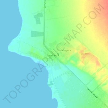
Name: Sudr Cape topographic map, elevation, terrain.

Location: Sudr Cape, South Sinai, 46612, Egypt (29.55349 32.67854 29.63349 32.75854)

Average elevation: 12 m

Minimum elevation: -1 m

Maximum elevation: 44 m

Other topographic maps

Click on a map to view its topography, its elevation and its terrain.

Abu Galum Protectorate

Egypt > South Sinai

Average elevation: 632 m

Al Tour City

Egypt > South Sinai

Average elevation: 50 m

Ras Muhammad National Park

Egypt > South Sinai

Average elevation: 112 m

Ras Sudr

Egypt > South Sinai

Average elevation: 17 m

Wadi Khuraytah

Egypt > South Sinai > Saint Catherine

Average elevation: 1,323 m

Ras Sudr

Egypt > South Sinai

Average elevation: 17 m

Gear up for your next adventure:

🥾Trail Running Boots - Durable shoes designed for trail running
🥾Hiking Shoes - Durable and comfortable shoes for trail hiking
💡LED Camping Lantern - Illuminate your campsite with long-lasting lanterns
🧰Survival Kit - Essential gear for emergencies in the wilderness
🥾Trekking Poles - Adjustable trekking poles to reduce knee stress and improve stability

As an Amazon Associate, this site earns from qualifying purchases at no extra cost to you.