Geolocate

Oliana topographic map

Click on the map to display elevation.

About this map

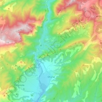
Name: Oliana topographic map, elevation, terrain.

Location: Oliana, Alt Urgell, Lleida, Catalonia, Spain (42.03935 1.29265 42.15163 1.36590)

Average elevation: 838 m

Minimum elevation: 424 m

Maximum elevation: 1,594 m

Gear up for your next adventure:

🛶Waterproof Dry Bags - Keep electronics and clothes dry during river crossings
🔋Emergency Crank Radio - Weather alerts and power without needing batteries
🧭GPS Handheld Device - Reliable GPS navigation for outdoor adventures
🧳Compression Sacks - Maximize space in your backpack by shrinking gear
🥾Mountain Trail Shoes - High-traction shoes for mountain trails

As an Amazon Associate, this site earns from qualifying purchases at no extra cost to you.