
Make a donation
Gear up for your next adventure:
As an Amazon Associate, this site earns from qualifying purchases at no extra cost to you.
Mount Holly topographic map
Click on the map to display elevation.
Make a donation
Gear up for your next adventure:
As an Amazon Associate, this site earns from qualifying purchases at no extra cost to you.
About this map
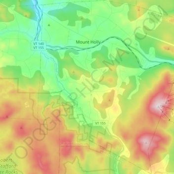
Name: Mount Holly topographic map, elevation, terrain.
Location: Mount Holly, Rutland County, Vermont, United States (43.35331 -72.87612 43.48364 -72.72256)
Average elevation: 588 m
Minimum elevation: 313 m
Maximum elevation: 1,011 m
Make a donation
Gear up for your next adventure:
As an Amazon Associate, this site earns from qualifying purchases at no extra cost to you.
Other topographic maps
Click on a map to view its topography, its elevation and its terrain.
Make a donation
Gear up for your next adventure:
As an Amazon Associate, this site earns from qualifying purchases at no extra cost to you.
Make a donation
Gear up for your next adventure:
As an Amazon Associate, this site earns from qualifying purchases at no extra cost to you.
Billings Mobile Manor
United States > Vermont > Rutland County > Rutland City
Average elevation: 211 m
Make a donation
Gear up for your next adventure:
As an Amazon Associate, this site earns from qualifying purchases at no extra cost to you.
West Tinmouth
United States > Vermont > Rutland County > Tinmouth > West Tinmouth
Average elevation: 419 m