Geolocate

Kochi topographic map

Click on the map to display elevation.

About this map

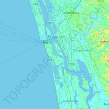
Name: Kochi topographic map, elevation, terrain.

Location: Kochi, Ernakulam district, Kerala, 682005, India (9.77137 76.10738 10.09137 76.42738)

Average elevation: 5 m

Minimum elevation: -4 m

Maximum elevation: 75 m

Gear up for your next adventure:

🎒Hiking Backpack - Lightweight and ergonomic backpacks for day hikes or multi-day treks
Bushcraft Tarp - Versatile emergency shelter or gear protection
🦶Hiking Shoe Insoles - Added support for high arches and long days on feet
🧢Beanie Hat - Keep your head warm in cold weather
💡Portable Camping Lamp - Rechargeable lamp for campsite lighting

As an Amazon Associate, this site earns from qualifying purchases at no extra cost to you.