Geolocate

Keriboul topographic map

Click on the map to display elevation.

About this map

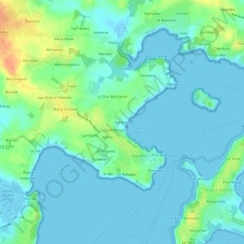
Name: Keriboul topographic map, elevation, terrain.

Location: Keriboul, Baden, Vannes, Morbihan, Bretagne, France métropolitaine, 56870, France (47.58788 -2.88943 47.62788 -2.84943)

Average elevation: 10 m

Minimum elevation: -3 m

Maximum elevation: 38 m

Other topographic maps

Click on a map to view its topography, its elevation and its terrain.

Gear up for your next adventure:

🎒Fully Waterproof Backpack - Total protection for photography gear and electronics
Lightweight Camping Tent - Portable shelter optimized for Canadian backcountry camping
🧭GPS Outdoor Watch - Smart watch for navigation and fitness tracking in nature
🥾Light Hiking Boots - Lightweight and comfortable boots for day hikes
🥾Durable Hiking Shoes - Long-lasting shoes for frequent hiking

As an Amazon Associate, this site earns from qualifying purchases at no extra cost to you.