Geolocate

Oberlichtenau topographic map

Click on the map to display elevation.

About this map

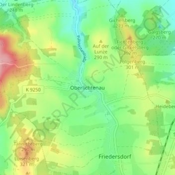
Name: Oberlichtenau topographic map, elevation, terrain.

Location: Oberlichtenau, Pulsnitz, Bautzen, Sachsen, 01896, Deutschland (51.19810 13.97357 51.23810 14.01357)

Average elevation: 269 m

Minimum elevation: 217 m

Maximum elevation: 356 m

Gear up for your next adventure:

🥘Camping Cookware Set - Compact nesting pots and pans for trail cooking
🥾Hiking Boots - Sturdy boots providing ankle support and traction on rugged trails
🎒Hiking Backpack - Lightweight and ergonomic backpacks for day hikes or multi-day treks
🧭GPS Tracker - Track your location in remote areas safely
🧰Multitool Knife - Compact and versatile tool for outdoor use

As an Amazon Associate, this site earns from qualifying purchases at no extra cost to you.