Geolocate

Mabalacat topographic map

Click on the map to display elevation.

About this map

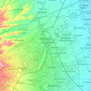
Name: Mabalacat topographic map, elevation, terrain.

Location: Mabalacat, Pampanga, Central Luzon, Philippines (15.15695 120.46176 15.26746 120.63451)

Average elevation: 117 m

Minimum elevation: 34 m

Maximum elevation: 405 m

Other topographic maps

Click on a map to view its topography, its elevation and its terrain.

Masantol

Philippines > Pampanga

Average elevation: 2 m

Santo Rosario

Philippines > Pampanga > Magalang

Average elevation: 49 m

Minalin

Philippines > Pampanga

Average elevation: 4 m

Manuali

Philippines > Pampanga > Porac

Average elevation: 199 m

Macabebe

Philippines > Pampanga

Average elevation: 3 m

Santo Niño

Philippines > Pampanga > San Simon

Average elevation: 4 m

Purok 1

Philippines > Pampanga > San Fernando > San Juan

Average elevation: 7 m

Floridablanca

Philippines > Pampanga

Average elevation: 24 m

Telabastagan

Philippines > Pampanga > San Fernando

Average elevation: 67 m

Gear up for your next adventure:

Camping Groundsheet - Protect your tent from moisture and dirt
🧢Hiking Hat - Sun-protective and breathable hats for long treks
❄️Traction Ice Cleats - Slip-on spikes for icy trails and winter hiking
🧭Orienteering Kit - Tools for map reading and navigation in the wild
Family Camping Tent - Spacious tent suitable for family camping trips

As an Amazon Associate, this site earns from qualifying purchases at no extra cost to you.