
Make a donation
Gear up for your next adventure:
As an Amazon Associate, this site earns from qualifying purchases at no extra cost to you.
Santivañez topographic map
Click on the map to display elevation.
Make a donation
Gear up for your next adventure:
As an Amazon Associate, this site earns from qualifying purchases at no extra cost to you.
Santivañez
Se encuentra conformado por paisajes de serranías, lomas y planicies con pendientes variables entre quebradas y zonas relativamente planas. Presenta rangos altitudinales que van entre 2.400 a 3.500 m s. n. m.
Make a donation
Gear up for your next adventure:
As an Amazon Associate, this site earns from qualifying purchases at no extra cost to you.
About this map
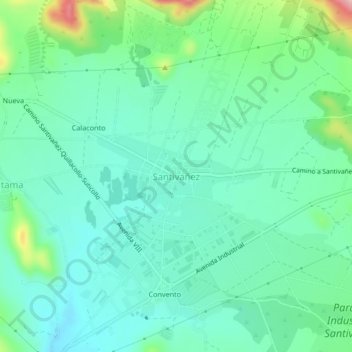
Name: Santivañez topographic map, elevation, terrain.
Location: Santivañez, Santiváñez, Capinota, Cochabamba, Bolivia (-17.57010 -66.26852 -17.53010 -66.22852)
Average elevation: 2,563 m
Minimum elevation: 2,517 m
Maximum elevation: 2,709 m
Make a donation
Gear up for your next adventure:
As an Amazon Associate, this site earns from qualifying purchases at no extra cost to you.