Geolocate

Fouché topographic map

Click on the map to display elevation.

About this map
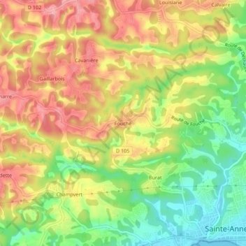
Name: Fouché topographic map, elevation, terrain.

Location: Fouché, Sainte-Anne, Pointe-à-Pitre, Guadeloupe, 97180, France (16.22281 -61.42347 16.26281 -61.38347)

Average elevation: 64 m

Minimum elevation: 0 m

Maximum elevation: 121 m

Other topographic maps

Click on a map to view its topography, its elevation and its terrain.

Mara Lamarre

France > Guadeloupe > Sainte-Anne > Deshauteurs

Average elevation: 90 m

Sainte-Anne

France > Guadeloupe > Sainte-Anne

Average elevation: 37 m

Gear up for your next adventure:

🦶Anti-Blister Balm - Prevents friction and hotspots during long ascents
💡Solar Camping Lamp - Eco-friendly lighting for campsites
⛺Bushcraft Tarp - Versatile emergency shelter or gear protection
🥾Waterproof Hiking Boots - Essential footwear for rugged terrain and wet Canadian trails
⛺Camping Groundsheet - Protect your tent from moisture and dirt

As an Amazon Associate, this site earns from qualifying purchases at no extra cost to you.