Geolocate

Oakey topographic map

Click on the map to display elevation.

About this map

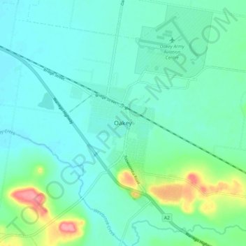
Name: Oakey topographic map, elevation, terrain.

Location: Oakey, Toowoomba Regional, Queensland, Australia (-27.47601 151.67891 -27.39601 151.75891)

Average elevation: 410 m

Minimum elevation: 391 m

Maximum elevation: 484 m

Other topographic maps

Click on a map to view its topography, its elevation and its terrain.

Oakey

Australia > Queensland > Oakey

Average elevation: 415 m

Oakey

Australia > Queensland > Oakey

Average elevation: 415 m

Gear up for your next adventure:

🛶Kayak Dry Bag - Waterproof storage for kayaking adventures
🦌Outdoor Trail Camera - Monitor wildlife activity near your favorite spots
🧥Softshell Jacket - Windproof and breathable jacket for hiking
🦯Trekking Poles - Reduced impact on joints for steep topographic climbs
🥾Durable Hiking Shoes - Long-lasting shoes for frequent hiking

As an Amazon Associate, this site earns from qualifying purchases at no extra cost to you.