
Langgam topographic map
Interactive map
Click on the map to display elevation.
About this map
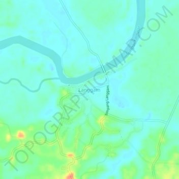
Name: Langgam topographic map, elevation, terrain.
Location: Langgam, Kecamatan Langgam, Pelalawan Regency, Riau, Indonesia (0.23131 101.70130 0.27131 101.74130)
Average elevation: 12 m
Minimum elevation: 1 m
Maximum elevation: 46 m
Other topographic maps
Click on a map to view its topography, its elevation and its terrain.
Sorek
Indonesia > Riau > Pelalawan Regency
Sorek, Kecamatan Pangkalan Kuras, Pelalawan Regency, Riau, 28382, Indonesia
Average elevation: 40 m
Bukit Agung
Indonesia > Riau > Pelalawan Regency
Bukit Agung, Kecamatan Langgam, Pelalawan Regency, Riau, Indonesia
Average elevation: 11 m