Geolocate

Frassinoro topographic map

Click on the map to display elevation.

About this map

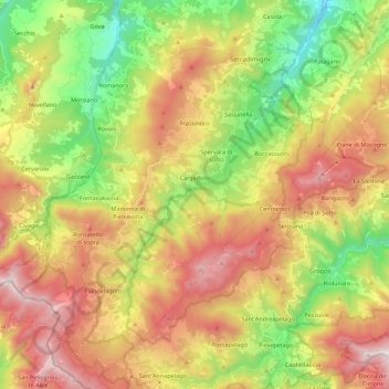
Name: Frassinoro topographic map, elevation, terrain.

Location: Frassinoro, Unione dei comuni del Distretto Ceramico, Modena, Emilia-Romagna, 41047, Italy (44.18680 10.46983 44.34592 10.60531)

Average elevation: 1,048 m

Minimum elevation: 440 m

Maximum elevation: 1,749 m

Other topographic maps

Click on a map to view its topography, its elevation and its terrain.

Bell'Italia

Italy > Emilia-Romagna > Modena > Maranello

Average elevation: 117 m

La Sega

Italy > Emilia-Romagna > Modena > Pievepelago > La Sega

Average elevation: 1,266 m

Gear up for your next adventure:

🧥Thermal Fleece Jacket - Versatile insulation for changing mountain temperatures
🕶️Polarized Sunglasses - Protect your eyes with durable polarized lenses
🥾Waterproof Hiking Shoes - Durable shoes for wet and rugged trails
🪑Ultralight Camping Stool - Compact seating for rest stops during long hikes
🔥Emergency Fire Starter - Reliable ignition source for all weather conditions

As an Amazon Associate, this site earns from qualifying purchases at no extra cost to you.