
Thank you for supporting this site ❤️
Make a donation
Make a donation
Gear up for your next adventure:
As an Amazon Associate, this site earns from qualifying purchases at no extra cost to you.
Keyport topographic map
Click on the map to display elevation.
Thank you for supporting this site ❤️
Make a donation
Make a donation
Gear up for your next adventure:
As an Amazon Associate, this site earns from qualifying purchases at no extra cost to you.
About this map
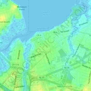
Name: Keyport topographic map, elevation, terrain.
Location: Keyport, Monmouth County, New Jersey, 07735, United States (40.42261 -74.21806 40.44738 -74.18353)
Average elevation: 6 m
Minimum elevation: -3 m
Maximum elevation: 19 m
Thank you for supporting this site ❤️
Make a donation
Make a donation
Gear up for your next adventure:
As an Amazon Associate, this site earns from qualifying purchases at no extra cost to you.
Other topographic maps
Click on a map to view its topography, its elevation and its terrain.
Candlewood
United States > New Jersey > Monmouth County > Howell Township > Candlewood
Average elevation: 33 m