Geolocate

Coker topographic map

Click on the map to display elevation.

About this map

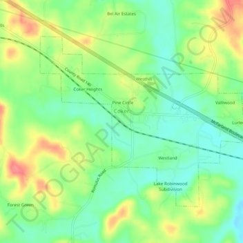
Name: Coker topographic map, elevation, terrain.

Location: Coker, Tuscaloosa County, Alabama, United States (33.22992 -87.70331 33.25817 -87.65540)

Average elevation: 68 m

Minimum elevation: 38 m

Maximum elevation: 112 m

Other topographic maps

Click on a map to view its topography, its elevation and its terrain.

Ralph

United States > Alabama > Tuscaloosa County

Average elevation: 60 m

South Ridge

United States > Alabama > Tuscaloosa County

Average elevation: 60 m

Bull City

United States > Alabama > Tuscaloosa County

Average elevation: 161 m

Carmel Bay

United States > Alabama > Tuscaloosa County

Average elevation: 82 m

Gear up for your next adventure:

🗺️Topographic Maps - Detailed maps to explore trails, mountains, and wilderness areas
🧢Outdoor Visor - Breathable visor for sunny hikes
🧴First Aid Kit - Essential first aid supplies for outdoor emergencies
🛁Quick-Dry Microfiber Towel - Space-saving towel that dries rapidly on the move
🦶Anti-Blister Balm - Prevents friction and hotspots during long ascents

As an Amazon Associate, this site earns from qualifying purchases at no extra cost to you.