
Make a donation
Gear up for your next adventure:
As an Amazon Associate, this site earns from qualifying purchases at no extra cost to you.
Guadalcanal Island topographic map
Click on the map to display elevation.
Make a donation
Gear up for your next adventure:
As an Amazon Associate, this site earns from qualifying purchases at no extra cost to you.
Guadalcanal Island
Guadalcanal is the largest island in Solomon Islands, with a total land area of 5,302 km2 (2,047 sq mi), and has a population of 155,605 people, making it the second-most populous island in the country after Malaita. Mount Popomanaseu is the island's highest point and the highest in Solomon Islands, with an elevation of 7,661 ft (2,335 m) above sea level. The Mbokokimbo River is the island's longest river, with a total length of 98.7 km (61.3 mi).
Make a donation
Gear up for your next adventure:
As an Amazon Associate, this site earns from qualifying purchases at no extra cost to you.
About this map
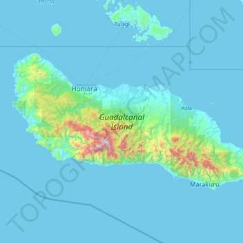
Name: Guadalcanal Island topographic map, elevation, terrain.
Location: Guadalcanal Island, Guadalcanal, Solomon Islands (-9.94642 159.58308 -9.25032 160.83433)
Average elevation: 117 m
Minimum elevation: -1 m
Maximum elevation: 2,285 m
Make a donation
Gear up for your next adventure:
As an Amazon Associate, this site earns from qualifying purchases at no extra cost to you.