
Make a donation
Gear up for your next adventure:
As an Amazon Associate, this site earns from qualifying purchases at no extra cost to you.
San Godenzo topographic map
Click on the map to display elevation.
Make a donation
Gear up for your next adventure:
As an Amazon Associate, this site earns from qualifying purchases at no extra cost to you.
San Godenzo
San Godenzo liegt etwa 50 km nordöstlich von Florenz im Bergland des Apennin, an der Grenze zur Provinz Forlì-Cesena (Emilia-Romagna), die hier durch den Gebirgspass Passo del Muraglione (907 Höhenmeter) vollzogen wird. Der Weg in die Emilia-Romagna führt hier über die Staatsstraße SS 67. Die dünn besiedelte Gemeinde umfasst ein Gebiet an den nördlichen Ausläufern des Monte Falterona, östlich des Sieve-Tals. Ungefähr ein Drittel des Territoriums gehört zum Foreste-Casentinesi-Nationalpark. Der Ort gehört zur Verwaltungsgemeinschaft Comunità montana Montagna Fiorentina und liegt am gleichnamigen Fluss San Godenzo. In der klimatischen Einordnung italienischer Gemeinden zählt der Ort zu der Zone E, 2891 GG.
Make a donation
Gear up for your next adventure:
As an Amazon Associate, this site earns from qualifying purchases at no extra cost to you.
About this map
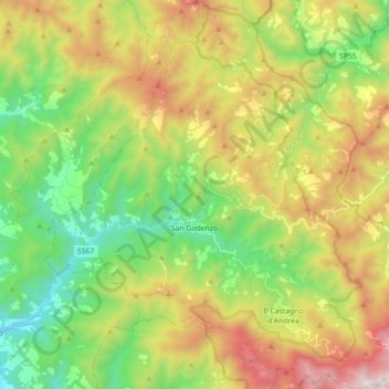
Name: San Godenzo topographic map, elevation, terrain.
Location: San Godenzo, Firenze, Toskana, Italien (43.87271 11.55200 43.99886 11.71891)
Average elevation: 747 m
Minimum elevation: 165 m
Maximum elevation: 1,639 m
Make a donation
Gear up for your next adventure:
As an Amazon Associate, this site earns from qualifying purchases at no extra cost to you.