Geolocate

Tipola topographic map

Click on the map to display elevation.

About this map

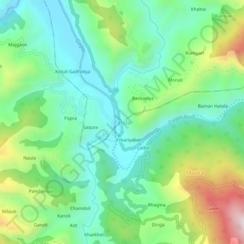
Name: Tipola topographic map, elevation, terrain.

Location: Tipola, Ranikhet, Almora District, Uttarakhand, India (29.66918 79.35210 29.70918 79.39210)

Average elevation: 1,070 m

Minimum elevation: 867 m

Maximum elevation: 1,524 m

Other topographic maps

Click on a map to view its topography, its elevation and its terrain.

Gagas

India > Uttarakhand > Ranikhet > Tipola

Average elevation: 1,125 m

Gear up for your next adventure:

🛶Waterproof Dry Bags - Keep electronics and clothes dry during river crossings
🔨Vehicle Emergency Tool - Safety tool for remote road trips to trailheads
🧢Beanie Hat - Keep your head warm in cold weather
🎒Hiking Daypack - Lightweight and durable backpacks for day trips and excursions
🎒Fully Waterproof Backpack - Total protection for photography gear and electronics

As an Amazon Associate, this site earns from qualifying purchases at no extra cost to you.