Geolocate

Moutas topographic map

Click on the map to display elevation.

About this map

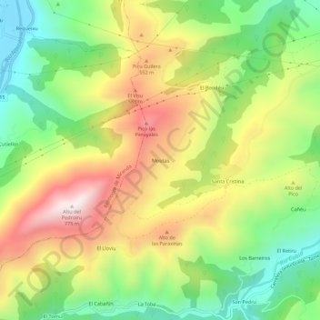
Name: Moutas topographic map, elevation, terrain.

Location: Moutas, Grado, 33858, España (43.33461 -6.14793 43.37461 -6.10793)

Average elevation: 376 m

Minimum elevation: 60 m

Maximum elevation: 766 m

Gear up for your next adventure:

🔋Emergency Crank Radio - Weather alerts and power without needing batteries
🧴Bear Spray Holster - Quick-access carry for essential Canadian wilderness safety
🥾Mountaineering Boots - Supportive boots for climbing and high-altitude hiking
Backpacking Tent - Lightweight tent for long-distance hiking trips
🛌Insulated Sleeping Pad - Critical thermal barrier between you and the cold ground

As an Amazon Associate, this site earns from qualifying purchases at no extra cost to you.