Kerckom-lez-Saint-Trond topographic map
Interactive map
Click on the map to display elevation.
About this map
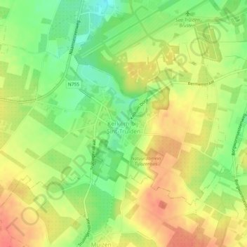
Name: Kerckom-lez-Saint-Trond topographic map, elevation, terrain.
Average elevation: 81 m
Minimum elevation: 52 m
Maximum elevation: 105 m

Click on the map to display elevation.
Name: Kerckom-lez-Saint-Trond topographic map, elevation, terrain.
Average elevation: 81 m
Minimum elevation: 52 m
Maximum elevation: 105 m