Geolocate

Pōkeno topographic map

Click on the map to display elevation.

About this map

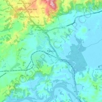
Name: Pōkeno topographic map, elevation, terrain.

Location: Pōkeno, Waikato District, Waikato, 2472, New Zealand (-37.28482 174.98195 -37.20482 175.06195)

Average elevation: 66 m

Minimum elevation: 3 m

Maximum elevation: 359 m

Other topographic maps

Click on a map to view its topography, its elevation and its terrain.

Hūnua Ranges

New Zealand > Waikato > Waikato District

Average elevation: 176 m

Lake Kimihia

New Zealand > Waikato > Waikato District

Average elevation: 34 m

Lake Whangape

New Zealand > Waikato > Waikato District

Average elevation: 16 m

Lake Rotokauri

New Zealand > Waikato > Waikato District

Average elevation: 35 m

Lake E

New Zealand > Waikato > Waikato District

Average elevation: 39 m

Gear up for your next adventure:

🧳Compression Sacks - Maximize space in your backpack by shrinking gear
🧥Ultralight Puffy Jacket - Maximum warmth that packs down to the size of an orange
🥾Hiking Leggings - Comfortable leggings for outdoor activities
🔨Vehicle Emergency Tool - Safety tool for remote road trips to trailheads
🚲Handlebar Phone Mount - View topographic-map.com live while cycling

As an Amazon Associate, this site earns from qualifying purchases at no extra cost to you.