Geolocate

Barsar topographic map

Click on the map to display elevation.

About this map

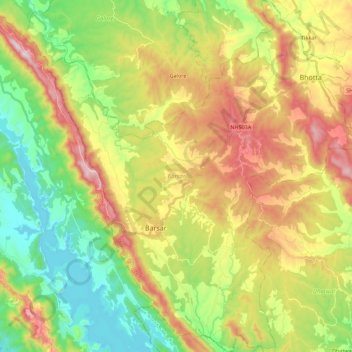
Name: Barsar topographic map, elevation, terrain.

Location: Barsar, Hamirpur, Himachal Pradesh, India (31.45988 76.39554 31.65022 76.59591)

Average elevation: 741 m

Minimum elevation: 471 m

Maximum elevation: 1,126 m

Gear up for your next adventure:

💧Filtered Water Bottle - Safe drinking water on the go
🧢Outdoor Visor - Breathable visor for sunny hikes
🔋Lithium AA Batteries - Long-lasting power that performs in extreme cold
Backpacking Tent - Lightweight tent for long-distance hiking trips
🧰Multitool Knife - Compact and versatile tool for outdoor use

As an Amazon Associate, this site earns from qualifying purchases at no extra cost to you.