
Lý Sơn topographic map
Interactive map
Click on the map to display elevation.
About this map
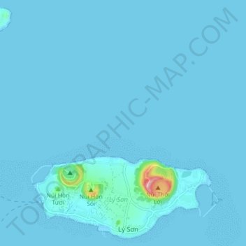
Name: Lý Sơn topographic map, elevation, terrain.
Location: Lý Sơn, Province de Quảng Ngãi, 54400, Viêt Nam (15.36904 109.07689 15.43327 109.14735)
Average elevation: 5 m
Minimum elevation: 0 m
Maximum elevation: 168 m
Other topographic maps
Click on a map to view its topography, its elevation and its terrain.
Lý Sơn
Viêt Nam > Province de Quảng Ngãi
Lý Sơn, Province de Quảng Ngãi, Viêt Nam
Average elevation: 10 m