Geolocate

Montouto topographic map

Click on the map to display elevation.

About this map

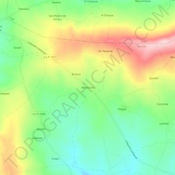
Name: Montouto topographic map, elevation, terrain.

Location: Montouto, Sirvián, Guntín, Lugo, Galicia, 27232, España (42.92187 -7.72878 42.96187 -7.68878)

Average elevation: 604 m

Minimum elevation: 506 m

Maximum elevation: 743 m

Gear up for your next adventure:

🧭Orienteering Kit - Tools for map reading and navigation in the wild
🧥Softshell Jacket - Windproof and breathable jacket for hiking
🥽Outdoor Goggles - Protective eyewear for outdoor activities
🥾Waterproof Hiking Boots - Boots keeping your feet dry in wet conditions
🧴Bear Spray Holster - Quick-access carry for essential Canadian wilderness safety

As an Amazon Associate, this site earns from qualifying purchases at no extra cost to you.