
Arusha topographic map
Click on the map to display elevation.
About this map
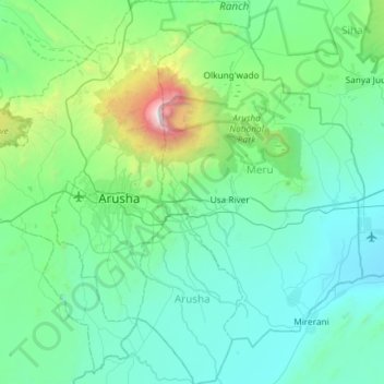
Name: Arusha topographic map, elevation, terrain.
Location: Arusha, Northern Zone, Tanzania (-3.65555 36.46981 -3.06639 36.88906)
Average elevation: 1,349 m
Minimum elevation: 869 m
Maximum elevation: 4,506 m
Other topographic maps
Click on a map to view its topography, its elevation and its terrain.
Arusha
Despite its proximity to the equator, Arusha's elevation of 1,400 metres (4,600 ft) on the southern slopes of Mount Meru keeps temperatures relatively low and alleviates humidity. Cool dry air is prevalent for much of the year. The temperature typically ranges between 10 and 30 °C (50 and 86 °F) with an…
Average elevation: 1,572 m
Ol Doinyo Lengai
Vegetation in the area consists mostly of grassland, which reaches an elevation of 1,750 metres (5,740 ft) above sea level. Volcanic ash from Ol Doinyo Lengai influences the surrounding landscape, favoring the growth of nutrient-rich plants. Precipitation falls during two wet seasons in March–May and…
Average elevation: 2,356 m
Arusha
Despite its proximity to the equator, Arusha's elevation of 1,400 metres (4,600 ft) on the southern slopes of Mount Meru keeps temperatures relatively low and alleviates humidity. Cool dry air is prevalent for much of the year. The temperature typically ranges between 10 and 30 °C (50 and 86 °F) with an…
Average elevation: 1,572 m
Ngorongoro Conservation Area
The southern and eastern boundaries of the Serengeti ecosystem are approximately defined by the rim of the East African Rift wall, which also prevents animal migration in these directions. In the topographical map, Lake Nyanza is the same as Lake Victoria in the Serengeti Ecosystem map.
Average elevation: 1,604 m
Arusha
Despite its proximity to the equator, Arusha's elevation of 1,400 metres (4,600 ft) on the southern slopes of Mount Meru keeps temperatures relatively low and alleviates humidity. Cool dry air is prevalent for much of the year. The temperature typically ranges between 10 and 30 °C (50 and 86 °F) with an…
Average elevation: 1,572 m