Geolocate

Bålsta topographic map

Click on the map to display elevation.

About this map

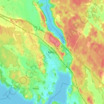
Name: Bålsta topographic map, elevation, terrain.

Location: Bålsta, Håbo kommun, Uppsala County, 74680, Sweden (59.52821 17.48936 59.60821 17.56936)

Average elevation: 28 m

Minimum elevation: -4 m

Maximum elevation: 64 m

Gear up for your next adventure:

🧥Insulated Jacket - Keep warm in cold outdoor conditions
🧭Orienteering Kit - Tools for map reading and navigation in the wild
🥾Light Hiking Boots - Lightweight and comfortable boots for day hikes
🦯Trekking Poles - Reduced impact on joints for steep topographic climbs
🪑Insulated Seat Pad - Protect your seat from cold rocks and wet logs

As an Amazon Associate, this site earns from qualifying purchases at no extra cost to you.