Geolocate

Acqualagna topographic map

Click on the map to display elevation.

About this map

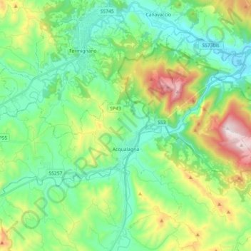
Name: Acqualagna topographic map, elevation, terrain.

Location: Acqualagna, Pesaro e Urbino, Marche, 61041, Italy (43.60087 12.54331 43.67515 12.72244)

Average elevation: 362 m

Minimum elevation: 117 m

Maximum elevation: 968 m

Other topographic maps

Click on a map to view its topography, its elevation and its terrain.

San Liberio

Italy > Marche > Pesaro e Urbino > Villanova

Average elevation: 97 m

Sterpeti

Italy > Marche > Pesaro e Urbino > Montefelcino

Average elevation: 107 m

Ponte Tavollo

Italy > Marche > Pesaro e Urbino > Pesaro

Average elevation: 43 m

Marotta

Italy > Marche > Pesaro e Urbino > Mondolfo > Marotta

Average elevation: 16 m

Gear up for your next adventure:

🧥Ultralight Puffy Jacket - Maximum warmth that packs down to the size of an orange
🏃Hydration Running Vest - Carry water and maps close to your body for speed
🧰Survival Kit - Essential gear for emergencies in the wilderness
🧊Insulated Water Bottle - Keeps drinks cold in summer and prevents freezing in winter
🧥Thermal Fleece Jacket - Versatile insulation for changing mountain temperatures

As an Amazon Associate, this site earns from qualifying purchases at no extra cost to you.