
Sayward topographic map
Click on the map to display elevation.
About this map
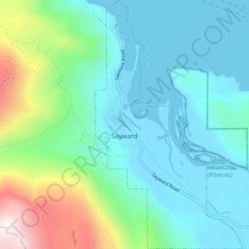
Name: Sayward topographic map, elevation, terrain.
Average elevation: 239 m
Minimum elevation: -1 m
Maximum elevation: 1,114 m
Other topographic maps
Click on a map to view its topography, its elevation and its terrain.
Read Island
Canada > British Columbia > Strathcona Regional District > Area B (Discovery Islands/Mainland Inlets) > Read Island
Average elevation: 38 m
Campbell River
Canada > British Columbia > Strathcona Regional District > Campbell River
Average elevation: 108 m
Mansons Landing
Canada > British Columbia > Strathcona Regional District > Area C (Cortes Island) > Mansons Landing
Average elevation: 32 m
Mount Clarence
Canada > British Columbia > Strathcona Regional District > Area B (Discovery Islands/Mainland Inlets)
Average elevation: 711 m
Tahsis
Canada > British Columbia > Strathcona Regional District > Tahsis > Tahsis
Average elevation: 252 m