
Make a donation
Gear up for your next adventure:
As an Amazon Associate, this site earns from qualifying purchases at no extra cost to you.
Arica topographic map
Click on the map to display elevation.
Make a donation
Gear up for your next adventure:
As an Amazon Associate, this site earns from qualifying purchases at no extra cost to you.
Arica
More than 20 km of beaches, many known for the quality of surfing, span across the Coastal Range in the northern sector. The harbored location makes these beaches unique from other cities in Chile in terms of topography.
Make a donation
Gear up for your next adventure:
As an Amazon Associate, this site earns from qualifying purchases at no extra cost to you.
About this map
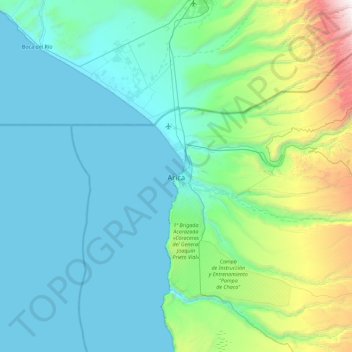
Name: Arica topographic map, elevation, terrain.
Average elevation: 523 m
Minimum elevation: 0 m
Maximum elevation: 3,622 m
Make a donation
Gear up for your next adventure:
As an Amazon Associate, this site earns from qualifying purchases at no extra cost to you.
Other topographic maps
Click on a map to view its topography, its elevation and its terrain.
Caleta Camarones
Chile > Arica y Parinacota Region > Provincia de Arica > Camarones
Average elevation: 188 m