
Ranni topographic map
Click on the map to display elevation.
Ranni
Ranni is located at 9°23′N 76°49′E / 9.38°N 76.81°E / 9.38; 76.81. It has an average elevation of 131 m (433 ft) above sea level. The location and elevation is measured around the township. However, towards the east, the elevation is much higher. River Pamba flows through Ranni. The township is situated on either side of the river. According to the Census of India, Ranni has a total of 1,004.61 square kilometres (387.88 sq mi). Out of the total area, 708 square kilometres (273.36 sq mi) or 70% is forest. This forest cover gives Ranni its green environment.
About this map
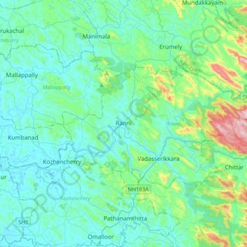
Name: Ranni topographic map, elevation, terrain.
Location: Ranni, Pathanamthitta, Kerala, India (9.30331 76.70632 9.46559 77.02065)
Average elevation: 93 m
Minimum elevation: 2 m
Maximum elevation: 579 m