Geolocate

Fleetwood topographic map

Click on the map to display elevation.

About this map

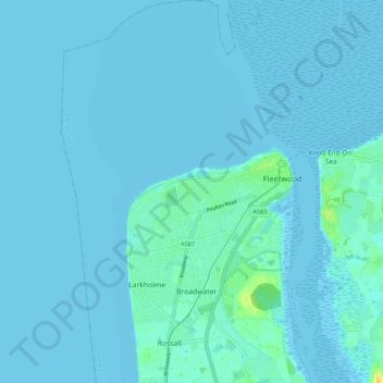
Name: Fleetwood topographic map, elevation, terrain.

Location: Fleetwood, Borough of Wyre, Lancashire, England, United Kingdom (53.89100 -3.06943 53.95395 -2.99914)

Average elevation: 2 m

Minimum elevation: -1 m

Maximum elevation: 24 m

Other topographic maps

Click on a map to view its topography, its elevation and its terrain.

Hardhorn

United Kingdom > England > Lancashire > Borough of Wyre

Average elevation: 13 m

Parlick

United Kingdom > England > Lancashire > Borough of Wyre

Average elevation: 251 m

Inskip

United Kingdom > England > Lancashire > Borough of Wyre

Average elevation: 14 m

Forton

United Kingdom > England > Lancashire > Borough of Wyre

Average elevation: 30 m

Gear up for your next adventure:

🧰Survival Kit - Essential gear for emergencies in the wilderness
🛰️Satellite Messenger - Emergency communication for areas with no cell service
🧊Portable Cooler - Keep food and drinks cold during outdoor adventures
💧Hydration Bladder - Hands-free hydration solution for long treks
🩹Moleskin Blister Pads - Direct protection for painful foot pressure points

As an Amazon Associate, this site earns from qualifying purchases at no extra cost to you.