Geolocate

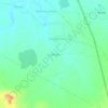
Ashta topographic map

Click on the map to display elevation.

About this map

Name: Ashta topographic map, elevation, terrain.

Location: Ashta, Ashta Tahsil, Sehore, Madhya Pradesh, India (22.98836 76.69646 23.03414 76.74416)

Average elevation: 496 m

Minimum elevation: 483 m

Maximum elevation: 506 m

Other topographic maps

Click on a map to view its topography, its elevation and its terrain.
Neelbad

India > Madhya Pradesh > Ashta Tahsil

Average elevation: 521 m

Lakhmipur

India > Madhya Pradesh > Ashta Tahsil

Average elevation: 484 m

Gear up for your next adventure:

🥫Freeze-Dried Meals - Lightweight, high-calorie nutrition for multi-day treks
🧤Rechargeable Heated Gloves - Extreme warmth for Canadian winter expeditions
🧊Insulated Water Bottle - Keeps drinks cold in summer and prevents freezing in winter
🔋Emergency Crank Radio - Weather alerts and power without needing batteries
⛺Camping Tent - Weather-resistant tents suitable for 2 to 6 people

As an Amazon Associate, this site earns from qualifying purchases at no extra cost to you.