
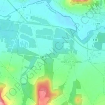
Villers-en-Prayères topographic map
Interactive map
Click on the map to display elevation.
About this map
Name: Villers-en-Prayères topographic map, elevation, terrain.
Average elevation: 67 m
Minimum elevation: 39 m
Maximum elevation: 152 m
Other topographic maps
Click on a map to view its topography, its elevation and its terrain.
Barbonval
France > Hauts-de-France > Aisne > Les Septvallons
Barbonval, Les Septvallons, Soissons, Aisne, Hauts-de-France, France métropolitaine, 02160, France
Average elevation: 119 m
Barbonval
France > Hauts-de-France > Aisne > Les Septvallons
Barbonval, Longueval-Barbonval, Les Septvallons, Soissons, Aisne, Hauts-de-France, France métropolitaine, 02160, France
Average elevation: 119 m