
Saint-Pierre topographic map
Interactive map
Click on the map to display elevation.
About this map
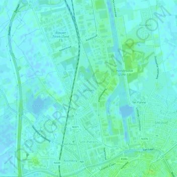
Name: Saint-Pierre topographic map, elevation, terrain.
Location: Saint-Pierre, Bruges, Flandre-Occidentale, Flandre, Belgique (51.21725 3.18833 51.25258 3.22725)
Average elevation: 3 m
Minimum elevation: -4 m
Maximum elevation: 9 m
Other topographic maps
Click on a map to view its topography, its elevation and its terrain.
Saint-André
Belgique > Flandre-Occidentale > Bruges > Bruges
Saint-André, Bruges, Flandre-Occidentale, Flandre, Belgique
Average elevation: 8 m
Bruges
Belgique > Flandre-Occidentale > Bruges > Bruges
Bruges, Flandre-Occidentale, Flandre, 8000, Belgique
Average elevation: 7 m