
Make a donation
Gear up for your next adventure:
As an Amazon Associate, this site earns from qualifying purchases at no extra cost to you.
Reichmannsdorf topographic map
Click on the map to display elevation.
Make a donation
Gear up for your next adventure:
As an Amazon Associate, this site earns from qualifying purchases at no extra cost to you.
About this map
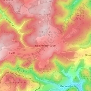
Name: Reichmannsdorf topographic map, elevation, terrain.
Average elevation: 646 m
Minimum elevation: 445 m
Maximum elevation: 757 m
Make a donation
Gear up for your next adventure:
As an Amazon Associate, this site earns from qualifying purchases at no extra cost to you.
Other topographic maps
Click on a map to view its topography, its elevation and its terrain.
Schmiedefeld
Deutschland > Thüringen > Landkreis Saalfeld-Rudolstadt > Saalfeld/Saale
Schmiedefeld liegt im Thüringer Schiefergebirge zwischen den Städten Saalfeld (nördlich) und Sonneberg (südlich) am südöstlichen Abhang des 802 Meter hohen Rauhhügels in etwa 700 Metern Höhe. Südöstlich des Ortes fällt die Landschaft weiter ab bis hinunter ins klammartige Tal des Geberbachs.
Average elevation: 678 m
Wittgendorf
Deutschland > Thüringen > Landkreis Saalfeld-Rudolstadt > Saalfeld/Saale
Wittgendorf liegt oberhalb des Sorbitztales im Naturpark Thüringer Wald. Der höchste Berg im Gemeindegebiet ist der Talberg mit einer Höhe von 602 m. Nachbargemeinden sind Volkmannsdorf, Rohrbach und Döschnitz. Unterhalb des Ortes entspringt der Elschnitztalbach, welcher bei Rohrbach nach vier Kilometern…
Average elevation: 511 m