
Make a donation
Gear up for your next adventure:
As an Amazon Associate, this site earns from qualifying purchases at no extra cost to you.
les Agudes topographic map
Click on the map to display elevation.
Make a donation
Gear up for your next adventure:
As an Amazon Associate, this site earns from qualifying purchases at no extra cost to you.
About this map
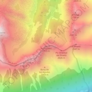
Name: les Agudes topographic map, elevation, terrain.
Location: les Agudes, Espot, Pallars Sobirá, Lérida, Cataluña, España (42.59846 1.02754 42.59856 1.02764)
Average elevation: 2,374 m
Minimum elevation: 1,654 m
Maximum elevation: 2,856 m
Make a donation
Gear up for your next adventure:
As an Amazon Associate, this site earns from qualifying purchases at no extra cost to you.
Other topographic maps
Click on a map to view its topography, its elevation and its terrain.
Estany de Sant Maurici
España > Cataluña > Pallars Sobirá > Espot
Está situado a 1910 m de altitud, en el fondo de un circo glaciar. Recibe las aguas de los ríos y torrentes de Ratera, del Portarró y Subenuix, mientras que su emisario, el río Escrita, drena el valle de Espot hasta el Noguera Pallaresa. Se encuentra dentro de un circo de origen glaciar en la región…
Average elevation: 2,179 m