

Make a donation
Gear up for your next adventure:
As an Amazon Associate, this site earns from qualifying purchases at no extra cost to you.
Ottersum topographic map
Click on the map to display elevation.
Make a donation
Gear up for your next adventure:
As an Amazon Associate, this site earns from qualifying purchases at no extra cost to you.
Ottersum
Ottersum ligt op de rechteroever van de Niers, op ongeveer 9 meter hoogte. Ten zuiden van deze rivier ligt een zandig bosgebied op ongeveer 14 meter hoogte, waar zich het complex van Maria Roepaan bevindt. Ten noorden van Ottersum ligt een voormalig moerassig gebied, een grootschalig landbouwgebied, waar Aaidonkse Beek en Spiekerbeek herinneren aan een vroegere bedding van de Niers. Ten noorden van deze vlakte rijst aan de Duitse zijde van de grens het Reichswald op.
Make a donation
Gear up for your next adventure:
As an Amazon Associate, this site earns from qualifying purchases at no extra cost to you.
About this map
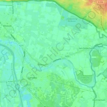
Name: Ottersum topographic map, elevation, terrain.
Location: Ottersum, Gennep, Limburg, Nederland (51.67824 5.97183 51.73929 6.03230)
Average elevation: 14 m
Minimum elevation: 4 m
Maximum elevation: 40 m
Make a donation
Gear up for your next adventure:
As an Amazon Associate, this site earns from qualifying purchases at no extra cost to you.
Other topographic maps
Click on a map to view its topography, its elevation and its terrain.
