Geolocate

Dolores topographic map

Click on the map to display elevation.

About this map

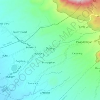
Name: Dolores topographic map, elevation, terrain.

Location: Dolores, Quezon, Calabarzon, 4326, Philippines (13.97572 121.36112 14.05572 121.44112)

Average elevation: 268 m

Minimum elevation: 62 m

Maximum elevation: 1,112 m

Gear up for your next adventure:

🚲Bike Repair Kit - Essential tools for on-trail mechanical issues
Camping Tent - Weather-resistant tents suitable for 2 to 6 people
🥾Trekking Boots - Durable boots for long-distance trekking
🕶️Polarized Sunglasses - Reduces glare from snow and water at high elevations
🌡️Emergency Mylar Blankets - Compact thermal protection for unexpected nights outdoors

As an Amazon Associate, this site earns from qualifying purchases at no extra cost to you.