
Make a donation
Gear up for your next adventure:
As an Amazon Associate, this site earns from qualifying purchases at no extra cost to you.
Altındağ topographic map
Click on the map to display elevation.
Make a donation
Gear up for your next adventure:
As an Amazon Associate, this site earns from qualifying purchases at no extra cost to you.
About this map
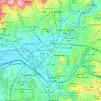
Name: Altındağ topographic map, elevation, terrain.
Location: Altındağ, Ankara, Central Anatolia Region, 06070, Turkey (39.91380 32.81531 39.99380 32.89531)
Average elevation: 904 m
Minimum elevation: 833 m
Maximum elevation: 1,122 m
Make a donation
Gear up for your next adventure:
As an Amazon Associate, this site earns from qualifying purchases at no extra cost to you.
Other topographic maps
Click on a map to view its topography, its elevation and its terrain.
Gençlik Parkı
The 27.5 ha (68 acres) park is almost at the center of Ankara. Its altitude is about 850 m (2,790 ft), which makes it one of the lowest points in Ankara. It is surrounded by Ulus Square to the north, the Ankara Opera House (formerly Ankara Exhibition Building) to the east, Selim Sırrı Tarcan Sport Hall and…
Average elevation: 870 m