Geolocate

Baños del Inca topographic map

Click on the map to display elevation.

About this map

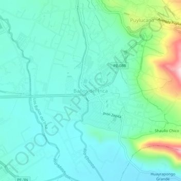
Name: Baños del Inca topographic map, elevation, terrain.

Location: Baños del Inca, Los Baños del Inca, Cajamarca, 06000, Perú (-7.18378 -78.48478 -7.14378 -78.44478)

Average elevation: 2,692 m

Minimum elevation: 2,619 m

Maximum elevation: 2,965 m

Other topographic maps

Click on a map to view its topography, its elevation and its terrain.

Río Chonta

Perú > Cajamarca > Los Baños del Inca

Average elevation: 3,082 m

Gear up for your next adventure:

🔦UV Flashlight - Detect minerals or specific insects in the dark
🛶Canoe Life Vest - Safety vest for water sports
🩹Compact First Aid Kit - Pre-packed essentials for common trail injuries
🥾Trekking Poles - Adjustable trekking poles to reduce knee stress and improve stability
🦶Anti-Blister Balm - Prevents friction and hotspots during long ascents

As an Amazon Associate, this site earns from qualifying purchases at no extra cost to you.