Geolocate

Huajuapan topographic map

Click on the map to display elevation.

About this map

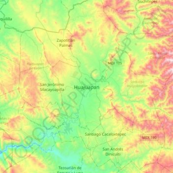
Name: Huajuapan topographic map, elevation, terrain.

Location: Huajuapan, Huajuapan de León, Oaxaca, 69000, Mexico (17.64885 -97.93806 17.96885 -97.61806)

Average elevation: 1,846 m

Minimum elevation: 1,369 m

Maximum elevation: 2,640 m

Gear up for your next adventure:

🚑Survival Whistle - Signal for help across long distances in mountains
🧥Ultralight Puffy Jacket - Maximum warmth that packs down to the size of an orange
🧴Waterproofing Spray - Restore the DWR coating on jackets and tents
🔭Compact Monocular - One-handed bird watching and trail spotting
🧥Waterproof Jacket - Lightweight rain jackets for hiking and outdoor activities

As an Amazon Associate, this site earns from qualifying purchases at no extra cost to you.