
Make a donation
Gear up for your next adventure:
As an Amazon Associate, this site earns from qualifying purchases at no extra cost to you.
Ravine des Citrons topographic map
Click on the map to display elevation.
Make a donation
Gear up for your next adventure:
As an Amazon Associate, this site earns from qualifying purchases at no extra cost to you.
About this map
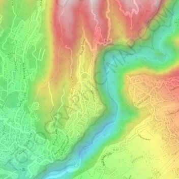
Name: Ravine des Citrons topographic map, elevation, terrain.
Average elevation: 504 m
Minimum elevation: 230 m
Maximum elevation: 797 m
Make a donation
Gear up for your next adventure:
As an Amazon Associate, this site earns from qualifying purchases at no extra cost to you.
Other topographic maps
Click on a map to view its topography, its elevation and its terrain.
L'entre-Deux
France > La Réunion > Entre-Deux
Le sommet de l'Entre-Deux est un sommet de montagne de l'île de La Réunion, un département et région d'outre-mer dans l'océan Indien. Situé le long du rempart montagneux du massif du Piton des Neiges appelé coteau Kerveguen, il culmine à 2 352 m d'altitude et constitue le tripoint où convergent les…
Average elevation: 1,885 m