
Thank you for supporting this site ❤️
Make a donation
Make a donation
Gear up for your next adventure:
As an Amazon Associate, this site earns from qualifying purchases at no extra cost to you.
Rinteln topographic map
Click on the map to display elevation.
Thank you for supporting this site ❤️
Make a donation
Make a donation
Gear up for your next adventure:
As an Amazon Associate, this site earns from qualifying purchases at no extra cost to you.
About this map
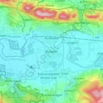
Name: Rinteln topographic map, elevation, terrain.
Location: Rinteln, Landkreis Schaumburg, Lower Saxony, 31737, Germany (52.14738 9.04046 52.22738 9.12046)
Average elevation: 101 m
Minimum elevation: 49 m
Maximum elevation: 311 m
Thank you for supporting this site ❤️
Make a donation
Make a donation
Gear up for your next adventure:
As an Amazon Associate, this site earns from qualifying purchases at no extra cost to you.