
Thank you for supporting this site ❤️
Make a donation
Make a donation
Gear up for your next adventure:
As an Amazon Associate, this site earns from qualifying purchases at no extra cost to you.
Belalcázar topographic map
Click on the map to display elevation.
Thank you for supporting this site ❤️
Make a donation
Make a donation
Gear up for your next adventure:
As an Amazon Associate, this site earns from qualifying purchases at no extra cost to you.
About this map
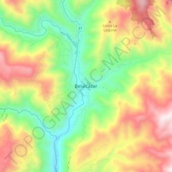
Name: Belalcázar topographic map, elevation, terrain.
Location: Belalcázar, Páez, Oriente, Cauca, RAP Pacífico, Colombia (2.60482 -76.01142 2.68482 -75.93142)
Average elevation: 1,885 m
Minimum elevation: 1,300 m
Maximum elevation: 2,632 m
Thank you for supporting this site ❤️
Make a donation
Make a donation
Gear up for your next adventure:
As an Amazon Associate, this site earns from qualifying purchases at no extra cost to you.
Other topographic maps
Click on a map to view its topography, its elevation and its terrain.