Geolocate

Cuxhaven topographic map

Click on the map to display elevation.

About this map

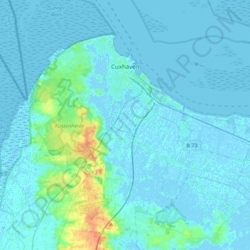
Name: Cuxhaven topographic map, elevation, terrain.

Location: Cuxhaven, Landkreis Cuxhaven, Lower Saxony, Germany (53.75888 8.55202 53.89229 8.86391)

Average elevation: 3 m

Minimum elevation: -4 m

Maximum elevation: 31 m

Gear up for your next adventure:

🪑Insulated Seat Pad - Protect your seat from cold rocks and wet logs
👟Sport Hiking Sandals - Breathable footwear for water crossings and camp rest
🧼Travel Hand Sanitizer - Keep hands clean when water is scarce
🥾Mountaineering Boots - Supportive boots for climbing and high-altitude hiking
Camping Tent - Weather-resistant tents suitable for 2 to 6 people

As an Amazon Associate, this site earns from qualifying purchases at no extra cost to you.