
Khakassia Nature Reserve topographic map
Interactive map
Click on the map to display elevation.
About this map
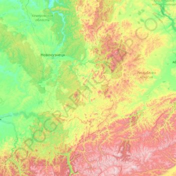
Name: Khakassia Nature Reserve topographic map, elevation, terrain.
Average elevation: 751 m
Minimum elevation: 140 m
Maximum elevation: 3,039 m
Khakasski is located in the Sayan montane conifer forests ecoregion, a region of mid-elevation mountains in the Altai-Sayan mountain range of central Asia. It lies between the Siberian taiga to the north and the Mongolian steppe to the south. This ecoregion is characterized by mountains desiccated with river valleys, high levels of precipitation, and high biodiversity. Flora is generally dependent on the elevation and terrain, with forests having three main subzones based on altitude: light needle-leaf sparse taiga, dark needle-leaf taiga, and dark taiga.